Vision that guides, response that protects. Real-time intelligent monitoring — the science of saving lives. We turn chaos into order.
A single browser tab replaces an entire operations room. Live drone feeds, asset tracking, 3D tactical maps, telemetry dashboards, encrypted team comms, and an AI copilot — all running in real-time with zero installation.
Runs in any modern browser. No downloads, no plugins — open the URL and you're operational.
Full PWA with local persistence. Stays operational when connectivity drops, syncs automatically on reconnect.
AES-256-GCM across all channels — video, voice, data, and commands. Per-session keys with zero-trust architecture.
From a single laptop to a full video wall. Detachable panels, customizable layouts, and multi-monitor support out of the box.
Real-time positions for every drone, vehicle, and operator on the map. Full situational awareness at a glance.
Every operator sees the same live picture. Shared maps, flags, tasks, and comms — synced across all stations in milliseconds.
Full command & control — live FPV, gimbal control, autonomous missions, and real-time telemetry integrated into a single operational interface.
Sub-150ms TACLINK peer-to-peer video. Dual camera support — wide-angle and zoom simultaneously. Picture-in-picture, full-screen, and grid modes.
Full command set through our native bridge. Virtual sticks, waypoint missions, gimbal rotation, camera triggers — all at 120Hz from any gamepad or joystick.
AI-planned search patterns uploaded directly to the flight controller. Grid, spiral, orbit, and corridor scans with automatic obstacle avoidance and RTH failsafes.
Thermal payload integration with live FLIR overlay, heat-signature detection, color palette switching, and AI-assisted person detection in darkness.
Google Maps + CesiumJS with real-time asset positions, flight paths, search zones, terrain elevation, and polygon management — 2D and full 3D.
TACLINK P2P video streaming. Multi-stream grid view with zero relay overhead.
Full flight status at 150ms via Protocol Buffers — attitude, GPS, battery, signal, obstacles, gimbal.
Fly from the browser via WebHID, Gamepad API, or native bridge at 120Hz.
Split-screen video grid, fleet battery dashboard, one-click recall all, automatic sector reassignment.
Continuous telemetry, video, and comms recording. Full replay with timeline scrubbing.
Organize operatives, drones, vehicles into teams. Assign sectors, checklists, tasks.
Geo-referenced markers, classified by type, shared across all stations instantly.
Military-grade heads-up display overlaid on live video — attitude, altitude, speed, compass, GPS, and battery at a glance.
Pre-mission, drone pre-flight, and emergency checklists. Live completion sync across all operators.
E2E encrypted team messaging with file sharing, map snapshots, and @mentions. Full audit trail.
Chronological feed of every event — comms, flags, asset movements, detections. Filterable and searchable.
Detailed flight records with telemetry snapshots, command history, and exportable post-mission reports.
Receive live video from field operatives' phone cameras and bodycams. Cycle streams, picture-in-picture, and full audit recording.
13+ grid presets from single panel to 3×3. Drag tiles, swap content, save per-mission layouts. Asymmetric and fullscreen modes.
Full PWA with IndexedDB persistence. When connectivity drops, P2P mesh sync keeps all stations in sync via LAN. Auto-replay on reconnect.
Conversational AI that understands your live mission. Knows battery, heading, assets, weather. Executes multi-step flight plans from natural language or voice.
"Thermal scan sector 7, creeping-line at 60m" "Flag thermal contact and dispatch ground team" "Expand search radius 500m, reassign Drone 3"On-device AI segmentation and object classification on live video — no cloud required.
AI-generated coverage paths with wind, battery, FOV constraints. Multi-drone deconfliction.
Military-grade SVS with TAWS terrain clearance overlaid on live video feed.
50+ live data layers fused into one tactical picture — from civilian flights to cyber threats.
Aggregates GDACS, NASA EONET, USGS, ACLED, UCDP, ReliefWeb, NVD and more. Every event classified by threat level with real geometry — fire footprints, flood extents, cyclone paths, and precise battle locations.
One-touch PTT with spatial audio. Each voice positioned by GPS bearing. Commander priority override.
Real-time Whisper in a Web Worker. Searchable log with keyword alerts.
TACLINK mesh with mDNS fallback. Direct peer connections even offline.
Emergency declaration triggers map beacon + Master Caution across all stations.
AES-256-GCM on top of DTLS. Per-operation keys — even a compromised relay sees nothing.
Hash-chained log of every command. Tamper-evident, exportable for legal review.
Role-based access with org hierarchy. Security rules enforce data isolation.
ARGUS adapts to every high-stakes environment — from wilderness search operations to urban tactical response.
Missing person searches across mountainous, forested, or rural terrain. Coordinate ground teams and drone sweeps with thermal detection, AI-assisted person recognition, and real-time search zone management to locate victims faster.
Active wildfire monitoring with real-time perimeter tracking, hotspot detection via thermal imaging, and evacuation coordination. Thermal and visual feeds give fire commanders full situational awareness of fire progression and crew safety.
Rapid damage assessment, survivor location, and resource coordination during floods, earthquakes, and severe weather events. Aerial reconnaissance provides commanders with real-time extent mapping and prioritized rescue zones.
High-security incidents, perimeter surveillance, overwatch, and coordinated tactical response. Drone reconnaissance, live operator tracking, encrypted comms, and AI-assisted threat detection in sensitive urban or rural environments.
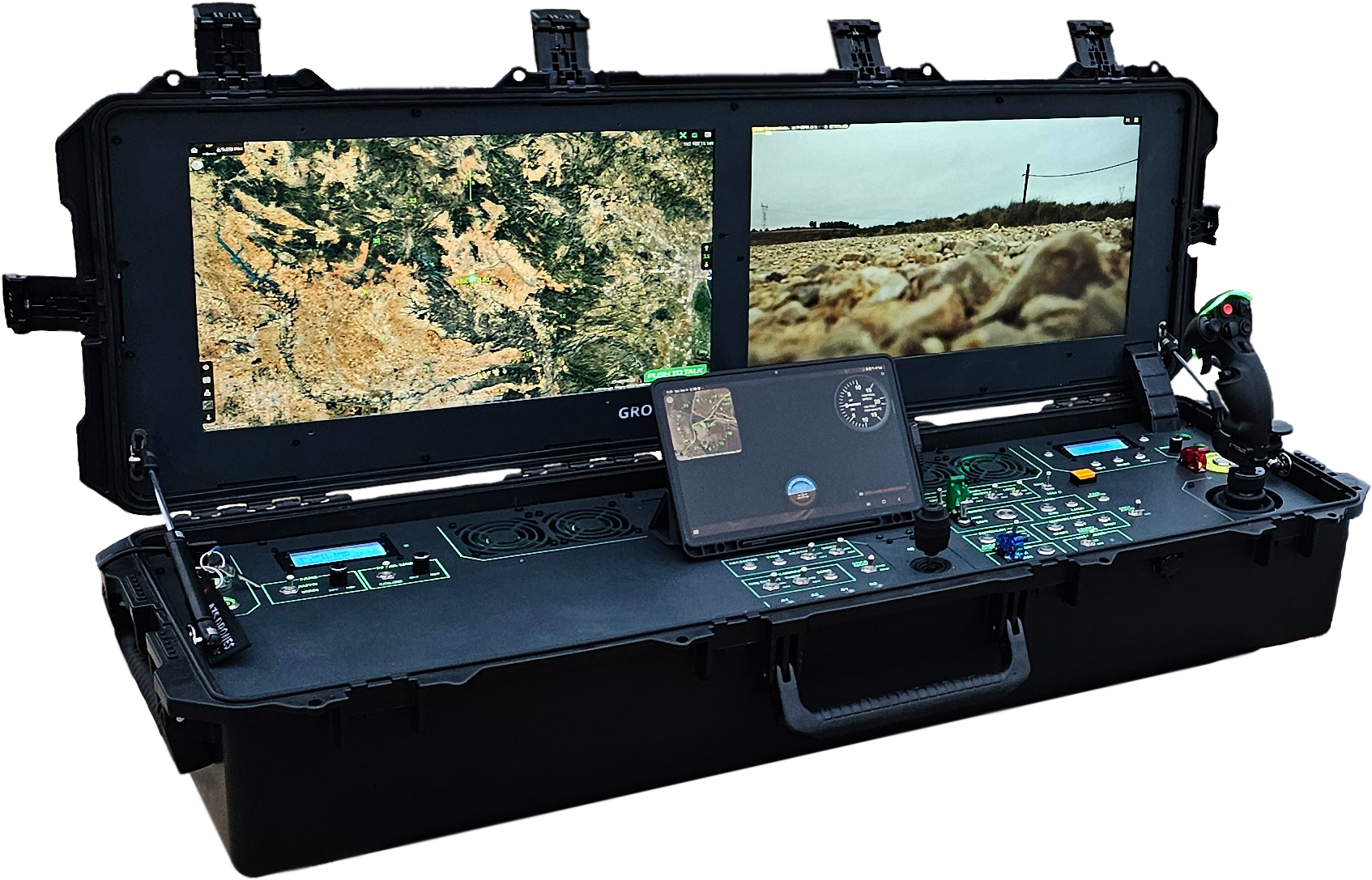
Purpose-built GCS hardware with dual high-brightness displays, integrated flight controls, and a ruggedized case designed for deployment in any environment. Set up a fully operational command post in minutes — in the field, on a vehicle, or inside a mobile command center.

ARGUS is developed in close collaboration with SAR Response Team — a non-profit association of volunteer search and rescue professionals. Their frontline expertise in real disaster scenarios directly shapes every feature, workflow, and decision in the platform. From field-tested comms protocols to mission-critical UI design, this partnership ensures ARGUS meets the demands of actual operations, not just theory.
"Where others see data, we see lives. Precision is not an option — it's our standard."
Your peace of mind is built on our vigilance. We lead the present to protect the future.
Available for search & rescue organizations, firefighting agencies, private security firms, surveillance & monitoring operations, defense contractors, and emergency response teams.
Request Early Access